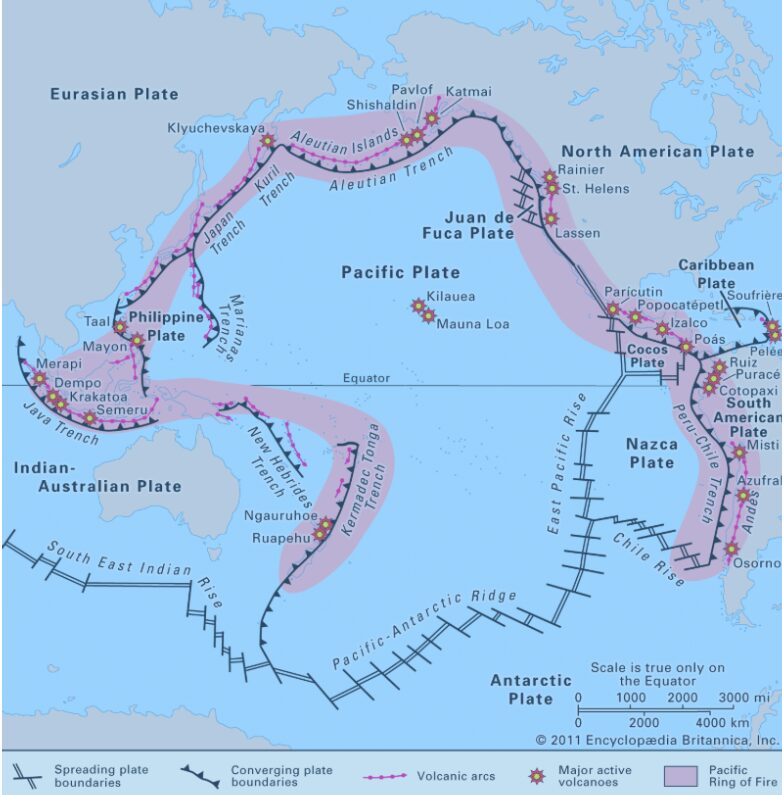
The Pacific Ring of Fire is one of the most geologically active regions on Earth, stretching around the edges of the Pacific Ocean in a vast horseshoe-shaped belt. It is famous for its frequent earthquakes, powerful volcanic eruptions, and tsunami-generating seismic events. Countries and island chains along this zone sit near active tectonic plate boundaries, where plates collide, slide past each other, or sink beneath one another. That constant geological movement is why the Ring of Fire continues to shape landscapes, disrupt communities, and remain one of the most closely monitored natural hazard regions in the world.
Although the name sounds dramatic, the Ring of Fire is not a single fault line or one connected chain of volcanoes. It is a broad region made up of subduction zones, trenches, volcanic arcs, and major fault systems. It runs from New Zealand through Indonesia, the Philippines, Japan, Russia, Alaska, the west coast of North America, Central America, and down the western edge of South America. Because of its scale and constant tectonic activity, this region has produced many of the largest earthquakes ever recorded and contains some of the world’s most active volcanoes.
The Pacific Ring of Fire Explained
The Pacific Ring of Fire surrounds much of the Pacific Ocean basin and covers roughly 40,000 kilometres. It is defined by intense tectonic activity rather than by political borders. This is where several major tectonic plates meet, including the Pacific Plate, Philippine Sea Plate, Nazca Plate, Cocos Plate, and parts of the North American, South American, Indo-Australian, and Eurasian plates.
Most earthquakes in this region occur because of plate movement. In many places, one plate is forced beneath another in a process known as subduction. This creates enormous pressure over time. When that pressure is suddenly released, it can trigger major earthquakes, volcanic eruptions, and in some cases tsunamis.
Why the Ring of Fire Is So Active
The Ring of Fire is so active because it sits on the boundaries of multiple tectonic plates. These plate boundaries are constantly shifting. Some plates collide, others pull apart, and some slide sideways past each other. The most dangerous earthquake zones are usually found where plates converge and one sinks beneath another.
This geological setting makes the region highly unstable. It is also why the Ring of Fire is associated with a very high concentration of volcanoes. Magma forms as descending plates melt and interact with the mantle, feeding volcanic systems along the Pacific rim.
Countries in the Pacific Ring of Fire
Many of the countries and territories commonly associated with the Ring of Fire include:
Chile, Peru, Mexico, the United States, Canada, Russia, Japan, the Philippines, Indonesia, Papua New Guinea, New Zealand, and parts of Antarctica.
These locations are among the most earthquake-prone and volcanically active in the world. Some areas experience frequent small tremors, while others face the risk of rare but catastrophic seismic events.
Earthquakes and Volcanoes in the Region
The Ring of Fire is widely regarded as the world’s most active earthquake and volcano belt. It is responsible for roughly 90% of the world’s earthquakes, and about 75% of the world’s active volcanoes are located along this region. That is why scientists, emergency agencies, and governments closely track seismic and volcanic activity across the Pacific basin.
Some volcanoes in the Ring of Fire erupt frequently, while others remain dormant for long periods before becoming active again. This mix of visible volcanic activity and hidden seismic pressure is what makes the region both scientifically important and potentially dangerous.
Some of the Largest Earthquakes Ever Recorded
1960 – Valdivia, Chile – Magnitude 9.5
Still the largest earthquake ever recorded, this event caused widespread destruction and generated a Pacific-wide tsunami.
1964 – Southern Alaska – Magnitude 9.2
One of the strongest earthquakes in recorded history, it caused severe ground failure, tsunamis, and major damage across Alaska.
2004 – Northern Sumatra, Indonesia – Magnitude 9.1
This earthquake triggered the devastating Indian Ocean tsunami and became one of the deadliest natural disasters in modern history.
2011 – Near the East Coast of Honshu, Japan – Magnitude 9.1
This earthquake and tsunami caused massive destruction in Japan and led to the Fukushima nuclear disaster.
2010 – Maule, Chile – Magnitude 8.8
A powerful subduction-zone earthquake that caused widespread damage and tsunami impacts along Chile’s coast.
1906 – Ecuador-Colombia – Magnitude 8.8
One of the great earthquakes of the early instrumental period, it also generated a damaging tsunami.
The 2011 Japan Earthquake and Tsunami
The earthquake that struck off the northeast coast of Honshu, Japan, on 11 March 2011 remains one of the most significant Ring of Fire disasters in recent history. It triggered a tsunami that reached the coast in less than an hour in some areas, overtopped coastal defences, and caused more than 18,000 deaths and disappearances.
It also changed how many countries think about early warning systems, evacuation planning, coastal engineering, and disaster preparedness. Since then, public awareness, hazard mapping, and real-time monitoring have improved in many parts of the Pacific region.
Latest Insights About the Pacific Ring of Fire
Today, the Ring of Fire remains a critical focus for geologists and disaster-response agencies because the seismic threat is ongoing, not historical. Modern monitoring systems now combine seismic sensors, GPS-based crustal movement tracking, satellite data, and tsunami warning networks to improve detection and response times.
Scientists continue to study not only large earthquakes but also clusters of smaller events, volcanic unrest, and stress transfer between fault systems to better understand where future major events may occur.
Another important insight is that earthquake risk is not determined only by magnitude. Depth, offshore location, local building standards, coastal exposure, and preparedness levels can greatly influence how destructive an event becomes.
Useful Tips and What This Means for Travellers, Residents and Coastal Communities
If you live in, work in, or travel through countries along the Pacific Ring of Fire, it is worth understanding the basic risks of earthquakes, volcanoes, and tsunamis. Know local evacuation routes, especially in coastal areas, pay attention to official warning systems, and do not ignore even moderate tremors near the shoreline.
In earthquake-prone regions, securing furniture, preparing emergency kits, and understanding where to take cover can make a real difference. For travellers, it is wise to check local advisories, hotel safety procedures, and seasonal conditions before visiting volcanic or coastal destinations.
The Ring of Fire is one of the most fascinating natural regions on Earth, but it is also a place where awareness and preparedness matter.